France
Introduction
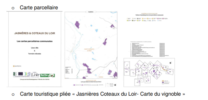
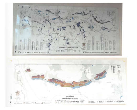
Mapping in relief helps to improve knowledge of the wine-growing region. On the other hand, it is a real communication tool for amateurs and the general public. It is an educational resource for winegrowers and wines of a designation and territory. In 2017, for example, the Groupement de Développement Viticulle de la Sarthe (GDVS) took over the technology for the Coteaux du Loir and Jasnières designations. The 3-D mapping of the sites is multi-purpose:
· Professionals for vine cultivation and marketing
· Tourists and inhabitants for the valorization of landscaped and heritage land (agri-landscape) and the improvement of the living environment It offers several variations: panoramic and confidential maps, tourist leaflets, evolution towards a smartphone application and potential addition of descriptive data of terroirs and vintages.
Presentation of the project
This three-dimensional mapping project of the vineyards and sites of the Coteaux du Loir and Jasnières AOC covers part of the Loir Valley (department of Sarthe in Pays de la Loire region) and part of the Indre et Loire region in Center Val de Loire region. The proration key was set at 85.21% for the Loir Valley territory. It is carried by the Groupement de Développement Viticulle de la Sarthe. The first objective is to give meaning to the vineyard by assessing the slopes, in particular the exposure of the slopes. With relief and perspective, perceptions are close to reality. The mapping information is thus accurate, reliable and entirely dedicated to the quality of terroirs and wines. The second objective is to develop wine-tourism activity in the territory, in particular through the Vineyard and Discovery label for the reception of groups, visits to cellars and other communication actions in the territory. However, the specificity of these places, known as the wines produced from these places, is not highlighted in isolation from the other tourist attractions of the wine-growing area, such as castles and manors or hiking and biking tours. The 3D tool opens up a new space for vintners to express themselves. The aim is to tell the story of the vineyard, its territory, the wines and the actors of this vineyard. The LEADER funding supported the application to the Conseil départemental de la Sarthe, another project funder.
Emblematic character of the project
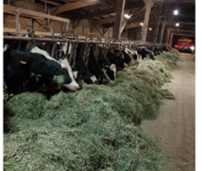
The project responds to the framework of our Action Sheet n°1: Strengthening the face-to-face economy of the Loir Valley and the AGIR approach for the South Sarthe. It enables producers in the Vallée du Loir vineyard to be equipped with 2D/3D mapping. They work on the quality of the terroirs and wines of the two appellations Coteaux du Loir and Jasnières in the context of their professional activity. On the other hand, the use of folded-map maps for tourist offices offers a development of economic activity linked to one of the main themes of the Loir Valley: wine tourism. At the strategic level, the Architectural and Landscape Charter of the Pays Vallée du Loir published in October 2013 integrates the accompaniment and preservation of wine-growing practice (fact sheet n°16) on axis n°2- Accompany a agriculture participating positively in the living environment. “The clearly affirmed image of agricultural identity is one of the major challenges of the Pays Vallée du Loir…. The vineyards of the Loir Valley enjoy 2 AOCs (Jasnières and Coteaux-du-Loir). It remains representative of a practice with a high tourist and wine value. It is also associated with the heritage elements that are the winegrowers’ houses and cellars. In a way, we can speak here of agri-landscape, by the visual impact that the grape variety lines produce and by the serenity that emerges from these landscapes “manufactured” by the vineyard.”
https://pays-valleeduloir.fr/fileadmin/Ressources/Document_cadre/Charte_Architecturale_Axe2.pdf
The obtaining of the Vignobles et Découverte ® label demonstrates the desire to be involved in the development of tourism related to wine. It is awarded by Atout France, following a recommendation from the Conseil Supérieur de l’OEnotourisme. Transferring to other LAGs is simple: 3-D mapping of specific areas for professional use, cross-referencing with other available or to be created maps for tourism use.
Pictures
Groupement de Développement Viticole de la Sarthe
GAL PAYS VALLEE DU LOIR
PAYS DE LA LOIRE